Long Island Sound Sentinel Monitoring for Climate Change Program
Background of the Sentinel Monitoring for Climate Change in Long Island Sound Program
Description of Long Island Sound Study Area
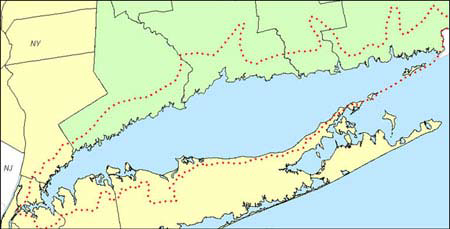
Long Island Sound (LIS) is a large urban estuary that separates Long Island from Connecticut. LIS is a unique estuary in that it has two connections to the Atlantic Ocean, The Race to the east and the East River to the west, as well as having several major rivers flowing into it. Eighty percent of the freshwater flowing into the Sound comes from these rivers. The area encompasses numerous coastal and estuarine habitats and provides critical feeding, nesting, breeding, and nursery habitat for numerous plant and animal species. The Sentinel Monitoring for Climate Change (SMCCP) does not encompass the entire LIS watershed area, but is not limited to the LIS study area or coastal boundary (see Figure 1). For the purpose of this document, we shall refer to the area of study as estuarine and coastal ecoregions.
As of 2010, nearly 9 million people live in the LIS watershed, with the Sound contributing approximately $8 billion annually to the regional economy through commercial and recreational activities. Population pressures have impacted the area through development and increases in certain pollutants such as hydrocarbons, pathogens, and PCBs.
Overview of the Long Island Sound Study
The Long Island Sound Study (LISS) was formed in 1985 by the United States Environmental Protection Agency (EPA), and the States of New York (NY) and Connecticut (CT) to restore and improve the environmental health of the Long Island Sound (LIS) ecosystems (Figure 1). This bi-state partnership includes federal and state agencies, multiple non-governmental organizations, universities and researchers, the general public, and other groups working to restore, conserve, and protect the Sound. A Comprehensive Conservation and Management Plan (CCMP) was completed in 1994 by the LISS that identified seven priority issues: low dissolved oxygen (hypoxia), toxic contamination, pathogen contamination, floatable debris, living resources and habitat management, land use and development, and public involvement and education. Significant advancements have been made in these areas; however, climate changewas not formally recognized as a major issue until recently. For more information on the LISS, see http://www.longislandsoundstudy.net
|
| Figure 1. Map of coastal boundary established by LISS, prepared by the Southern New England Coastal Program Office, United States Fish and Wildlife Service. |
Background of the Sentinel Monitoring for Climate Change in Long Island Sound Program
Since the development of the LISS CCMP in 1994, global climate change impacts have come to the forefront in current science and management issues. The complexities of a changing climate and the subsequent impacts on different ecosystems have caused many estuary programs to revisit their management plans to take into consideration regional climate changes. Since it is extremely difficult to scale down global climate models to the regional level, local-, watershed-, and state-level information on climate change impacts information was and is still largely unavailable. The SMCCP is a novel approach in that it combines available regional-scale predictions and climate drivers (top down) with local monitoring information (bottom up) to identify candidate sentinels of change. Current and predicted climate changes within LIS estuarine and coastal ecosystems include changes in: air and water temperatures; wind (speed and direction); precipitation and storm climatology; sea level rise rates; and water chemistry; followed by changes in habitats and biological systems (See Appendix B for details on predicted changes in the physical and biological systems of LIS). The importance of long-term monitoring to the understanding and planning for climate change impacts on LIS ecosystems are becoming more apparent. Baseline studies of many climate-related environmental indicators are either missing or incomplete making it difficult for scientists and resource managers to track changes and identify trends over time. Recognizing the importance of baseline indicators as well as long-term monitoring to track climate change impacts, the LISS proposed a sentinel monitoring for climate change program in Long Island Sound “as a means of quantifying environmental changes from climate change (Rozsa 2008).” The ecosystem-level approach to identifying climate change impacts on the LIS estuarine and coastal ecosystem has been novel among coastal climate-change programs in the United States.
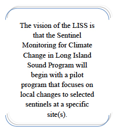 The vision of the LISS is that the SMCCP will begin with a pilot program that focuses on local changes to selected sentinels at a specific site(s) instead of trying to develop a region-wide monitoring and assessment program from the outset. Initially, the approach considered was to have one core location in each state for each basin of the Sound (western, central, eastern; total of six core sites) and “roving” stations around the core sites to give a broader range of information on local climate change effects. However, due to budget constraints, it was decided that the pilot program be focused on one site in each state on which future monitoring could be built and from which future monitoring could be expanded, pending additional or outside sources of funding. Such a pilot program would not be a mini-monitoring program in itself, but a small subset of a larger monitoring program. The vision of the LISS is that the SMCCP will begin with a pilot program that focuses on local changes to selected sentinels at a specific site(s) instead of trying to develop a region-wide monitoring and assessment program from the outset. Initially, the approach considered was to have one core location in each state for each basin of the Sound (western, central, eastern; total of six core sites) and “roving” stations around the core sites to give a broader range of information on local climate change effects. However, due to budget constraints, it was decided that the pilot program be focused on one site in each state on which future monitoring could be built and from which future monitoring could be expanded, pending additional or outside sources of funding. Such a pilot program would not be a mini-monitoring program in itself, but a small subset of a larger monitoring program.
A climate change vulnerability assessment, such as this SMCCP, is the first step towards adaptation. Implementation of the SMCCP will yield results on current conditions in LIS and, over time, will highlight resources or processes that are vulnerable to climate change. Once sentinel responses to climate change are identified, it is expected that the Management Conference partners will be able to develop recommendations for action based on significant early-warning findings. Current policy does not take into account the pressures of climate change on the LIS ecosystem and this monitoring program should yield results that will guide policy in the LIS estuary and larger watershed.
In October 2008, the LISS awarded the states of New York and Connecticut $75,000 each to develop an overarching strategy for their portion of the LIS watershed (year 1) and to implement a pilot program (year 2). At the February 2009 Scientific and Technical Advisory Committee meeting, it was agreed that this timeline was too ambitious and required an extension to allow for a complete strategy and thorough peer-review. It was agreed between New York and Connecticut representatives that both states would develop a larger sentinel monitoring strategy and, from that, develop a pilot program for initial implementation.
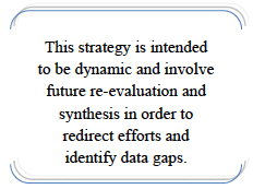
Initially there was some debate as to the utility of planning a comprehensive program when the planned funding level from LISS was only pilot in scale. However, the recommendations for a larger-scale program were recognized as crucial to guiding future efforts and taking advantage of future funding opportunities. Additionally, it was recognized that most environmental monitoring is not a comprehensive single program, but usually a combination of sources that leverage one another. This strategy is intended to be dynamic and involve future re-evaluation and synthesis in order to redirect efforts and identify data gaps.
Program Development
The SMCCP was originally proposed as a “sentinel site” project, with the selection of a location-based starting point and the secondary selection of appropriate parameters based on the chosen site. The process was inverted to first consider climate drivers and parameters and then choose appropriate sites based on these selected indicators/sentinels. There was also discussion as to how far inland monitoring could and should extend as the program was not intended to be limited to just the open water. Both work groups thought that the habitat and biota of the coastal fringe would be able to capture more change than other parts of the ecosystem (due to impacts of multiple climate change drivers such as sea level rise). It was envisioned from the beginning that an awardee for pilot implementation would be scouted through a RFP (request for proposals) process and that the awardee would be the best entity for site selection.
Later discussions among several LISS committees highlighted the potential advantages of choosing locations at Stewardship sites. In 2006, the Long Island Sound Stewardship Initiative (LISSI) identified 33 areas along the Sound with high ecological and recreational values (for map, please see http://longislandsoundstudy.net/issues-actions/stewardship/). The Sound’s estuarine and coastal habitats can be divided into beaches, tidal wetlands, tidal flats, subtidal habitats, open waters, and freshwater tidal habitats of tributaries. Coupling siting of sentinel monitoring locations in or around these stewardship areas would have the benefit of working in protected locations and would promote the long-term viability of this program.
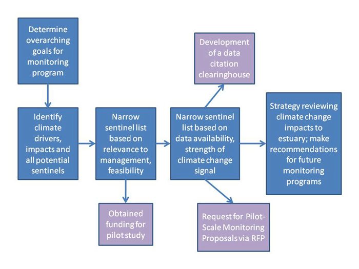 |
| Chart 1. This flow chart describes the sequential approach applied by the SMCCP work groups to create a comprehensive strategy for climate change monitoring in Long Island Sound (blue boxes). The purple boxes are additional projects undertaken by the bi-state work group, which developed out of steps in the strategy development process. Each step in the strategy development process was coordinated by the bi-state work group with scientific and technical input from the state level work groups. |
|